Beta

Now live on iOS TestFlight

Ride further and plan smarter.

Know your battery, elevation, and weather before you leave the driveway.

Vector
Vector
Vector
Vector
Vector
Vector
Vector
Vector
BG Image
BG Image

Plan

Plan

epic

epic

About Image
About Image
About Image
About Image
About Image
About Image
About Image
About Image

routes

routes

with

with

a

a

layout

layout

that

that

shows

shows

your

your

battery,

battery,

elevation,

elevation,

Vector

and

and

charging

charging

stops

stops

at

at

a

a

glance.

glance.

Built for e-bike riders.

#Weekend tourers

#Alpine riders

#Long distance

#Daily commuters

Vector
  • Icon

    Battery charged

  • BG Image
  • Icon

    Route planned

  • BG Image
  • Icon

    Charger located

  • BG Image
  • Icon

    Elevation checked

  • BG Image
  • Icon

    Weather clear

  • BG Image
  • Icon

    Stops added

  • BG Image
  • Icon

    Distance set

  • BG Image
  • Icon

    Ride ready

  • BG Image

Smart routing that fits into every ride. Battery aware planning, live charging stops, and weather forecasts help you go further with confidence.

Cloud
Cloud
Cloud

Routes with intelligence

A layout that keeps your ride clear.

Zyflow gives you everything you need before you leave. Battery range, elevation, charging stops, and weather for every kilometer.

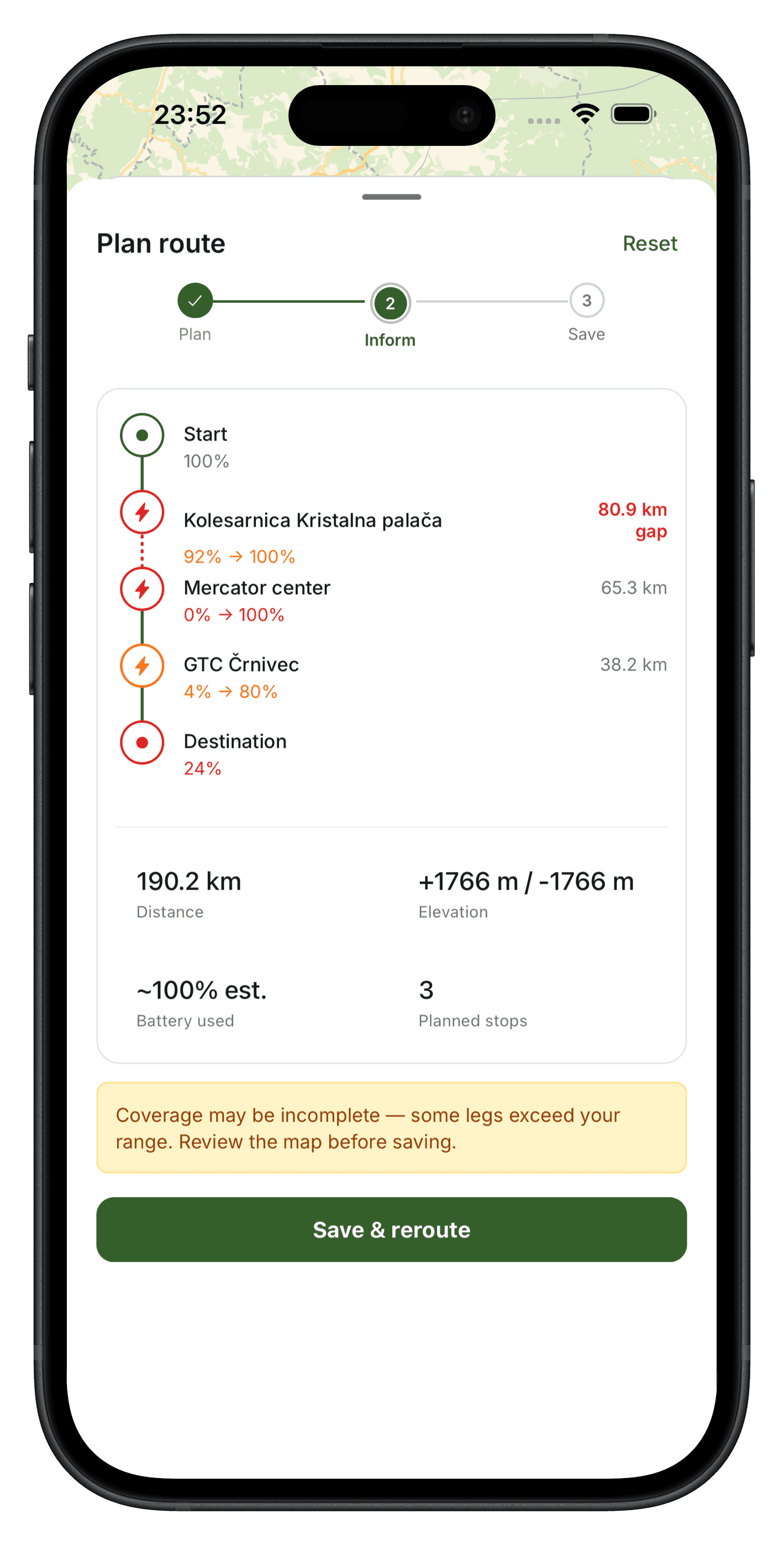
Battery-aware routing

Traditional apps ignore your battery. Miss a charge stop and your ride ends early.
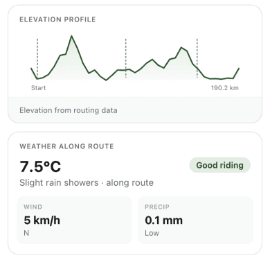
Vector
  • Icon

    Charger Located

  • Icon

    Battery Safe

  • Icon

    Elevation Checked

  • Icon

    Route Optimised

  • Icon

    Weather Clear

  • Icon

    Charger Located

  • Icon

    Battery Safe

  • Icon

    Elevation Checked

  • Icon

    Route Optimised

  • Icon

    Weather Clear

Elevation profile

A clear view of every climb ahead so you know exactly where your battery will drain fastest.

Route Profile

Ljubljana → Trieste

+1766 m

Total

0 km

Icon

Flat valley section

+45 m

45 km

Icon

Alpine climb

+890 m

89 km

Icon

Long descent

-650 m

134 km

Icon

Final climb

+831 m

05:00 PM

Icon

Stretch routine

10 minutes

10:00 PM

Icon

Plan tomorrow

5 minutes

0 km

Icon

Flat valley section

+45 m

09:00 AM

Icon

Drink 3 glasses of water

Before 11:00 AM

10:00 AM

Icon

Deep work session

60 minutes

11:30 AM

Icon

Read 10 pages

30 minutes

Route Profile

Ljubljana → Trieste

+1766 m

Total

0 km

Icon

Flat valley section

+45 m

45 km

Icon

Alpine climb

+890 m

89 km

Long descent

-650 m

134 km

Final climb

+831 m

05:00 PM

Stretch routine

10 minutes

10:00 PM

Plan tomorrow

5 minutes

0 km

Flat valley section

+45 m

09:00 AM

Drink 3 glasses of water

Before 11:00 AM

10:00 AM

Deep work session

60 minutes

11:30 AM

Read 10 pages

30 minutes

BG Image

Route planning

Plan multi-stop routes so your ride feels organised instead of overwhelming.

*Charging stops placed automatically based on your battery range.

Vector
Vector
Vector
BG Image

Live charging stops

Charger locations placed exactly where you need them, with detour time and plug type.

Nearest chargers

0%
0%
0%

Uptime

0%
0%
0%

Free

0%
0%
0%

Type 2

Chargers on route

3

Auto-placed by Zyflow

Chargers on route

3

Auto-placed by Zyflow

Avg detour

24 m

To nearest stop

Avg detour

24 m

To nearest stop

BG Image

Weather along route

Short, timely alerts that tell you exactly when and where conditions change on your ride.

Bell icon

54.8 km • Along your route

Thunderstorm in 30 km

Heavy rain expected near Logatec. Consider an early stop.

Got it

Reroute

  • Icon

    Rain in 20 km

    Light showers expected near Postojna.

  • Icon

    Headwind ahead

    Strong winds from 45 km. Adjust your pace.

  • Icon

    Temperature dropping

    Drops to 2°C after the mountain pass.

  • Icon

    Charger stop soon

    Next charging stop in 8 km on your right.

  • Icon

    Storm clearing

    Conditions improve after Logatec.

  • Icon

    Visibility low

    Fog reported near the summit. Ride carefully.

  • Icon

    Plan the next day

    A quick reset helps reduce stiffness.

  • Icon

    Evening reset

    Tidy up and prepare for tomorrow.

  • Icon

    Drink a glass of water

    You’re behind today’s hydration goal.

Built for every rider

Adapted for the way you ride

Icon

Alpine riders

Icon

Weekend tourers

Icon

Daily commuters

Icon

Long distance

For climbers tackling serious elevation where battery drain is hardest to predict.

+1766m

Elevation tracked per route

BG Image
Icon

Alpine riders

Icon

Weekend tourers

Icon

Daily commuters

Icon

Long distance

For climbers tackling serious elevation where battery drain is hardest to predict.

+1766m

Elevation tracked per route

BG Image

And for every kind of e-biker

#gravel riders

#MTB

#touring cyclists

#adventure seekers

#bike commuters

Real data, real coverage

Built on data that actually matters

7,400+

Charging & service locations mapped

Charging & service locations mapped

Cloud
Cloud
Cloud
00112
00001
02468
k
m

Longest beta route planned

00112
00001
02468
k
m

Longest beta route planned

00001
00000
00000
+

Beta riders testing now

00001
00000
00000
+

Beta riders testing now

00123
+

Countries covered so far

00123
+

Countries covered so far

Beta program

Why join as a beta rider

Beta riders shape the product directly. Your feedback decides what gets built next and you get early access to every feature before public launch.

BG Image
Phone
Phone
Phone
Phone
Phone
Icon

Free Forever

Beta riders keep full access free for life, no subscription when we launch.

Icon

Free Forever

Beta riders keep full access free for life, no subscription when we launch.

Icon

Direct Dev Access

Report bugs and request features directly to the team. We respond to everyone.

Icon

Direct Dev Access

Report bugs and request features directly to the team. We respond to everyone.

Icon

Shape the Roadmap

Your most-requested features get prioritised in the next release cycle.

Icon

Shape the Roadmap

Your most-requested features get prioritised in the next release cycle.

Icon

Early AI Access

Beta riders will be first to test AI route suggestions when we launch it.

Icon

Early AI Access

Beta riders will be first to test AI route suggestions when we launch it.

Common questions

Frequently asked questions

Icon

Can't find your answer?

How do I get access to the iOS beta?

Tap "Download on TestFlight" and you'll be redirected to Apple's TestFlight app. The whole process takes under 2 minutes.

How do I get access to the iOS beta?
Is Zyflow free during beta?
What e-bikes does Zyflow support?
When is Android coming?
How do I give feedback?

Ride further starting today

Download the beta, plan your first route, and tell us what you think.

Cloud Image
Cloud Image

Ride further starting today

Download the beta, plan your first route, and tell us what you think.

Cloud Image
Cloud Image

Ride further starting today

Download the beta, plan your first route, and tell us what you think.

Cloud Image
Cloud Image

Scan to download on iOS

QR Code
Cloud Image
Cloud Image

Scan to download on iOS

QR Code
Cloud Image
Cloud Image

Scan to download on iOS

QR Code
Cloud Image
Cloud Image
Cloud Image
Cloud Image
Cloud Image
Cloud Image
Cloud Image